
Airport Noise Contours
Noise levels can be computed at individual locations of interest, but to show how noise can vary over extended areas are often drawn on maps in terms of lines connecting points of the same decibel (dBA).
The image to the right shows a topographical map with elevation and terrain of the airport with an outline of the noise contour.
Click on the image to the right to view in larger detail. Then double click the image to zoom in or out.

Noise Contour Map Trim
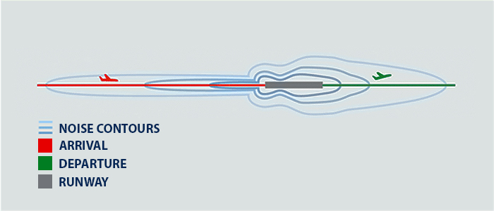
Similar to topographical maps showing the elevation of terrain in an area, these noise “contours” are useful for comparing aircraft noise exposure throughout an airport community. The shape of noise contours depends on many factors, but are influenced by things like whether more arriving or departing aircraft are flying over an area.
Contour maps can be seen by selecting from the list on the right. Not all airports have maps provided to us at this time. We will be updating the airport contour map links once received.
Those indicated as Not Provided do not have a contour map link provided at this time. To find an airport, use the search option above the listing on the right to search by Airport Name, Identifier, Zip code or City. Those that have contour maps will be indicated with “View Contour Map” and colored light blue.
Airport Contour Maps
| Identifier | Airport | Contour Map Link |
|---|---|---|
| MFV | Accomack County Airport | Not Provided |
| BKT | Allan C. Perkinson Municipal Airport | Not Provided |
| MTV | Blue Ridge Regional Airport | Not Provided |
| GDY | Breaks Regional Airport | Not Provided |
| VBW | Bridgewater Air Park | Not Provided |
| 0V4 | Brookneal-Campbell County Airport | Not Provided |
| LVL | Brunswick County Airport | Not Provided |
| CHO | Charlottesville-Albemarle Airport | Not Provided |
| CXE | Chase City Municipal Airport | Not Provided |
| CPK | Chesapeake Regional Airport | View Contour Map |
| W81 | Crewe Municipal Airport | Not Provided |
| CJR | Culpeper Regional Airport | View Contour Map |
| DAN | Danville Regional Airport | View Contour Map |
| PTB | Dinwiddie County Airport | View Contour Map |
| W13 | Eagle's Nest Aiport | Not Provided |
| EMV | Emporia-Greensville Regional Airport | Not Provided |
| W24 | Falwell Airport | Not Provided |
| FVX | Farmville Regional Airport | View Contour Map |
| FKN | Franklin Regional Airport | Not Provided |
| FRR | Front Royal-Warren County Airport | Not Provided |
| GVE | Gordonsville Municipal Airport | Not Provided |
| PVG | Hampton Roads Executive Airport | Not Provided |
| OFP | Hanover County Municipal Airport | Not Provided |
| W75 | Hummel Field | Not Provided |
| HSP | Ingalls Field | Not Provided |
| 7W4 | Lake Anna Airport | Not Provided |
| W63 | Lake Country Regional Airport | Not Provided |
| 0VG | Lee County Airport | Not Provided |
| JYO | Leesburg Executive Airport | View Contour Map |
| LNP | Lonesome Pine Airport | Not Provided |
| LKU | Louisa County Airport | View Contour Map |
| W31 | Lunenburg County Airport | Not Provided |
| LUA | Luray Caverns Airport | Not Provided |
| LYH | Lynchburg Regional Airport | Not Provided |
| HEF | Manassas Regional Airport | View Contour Map |
| AVC | Mecklenburg-Brunswick Regional Airport | Not Provided |
| FYJ | Middle Peninsula Regional Airport | Not Provided |
| MKJ | Mountain Empire Airport | View Contour Map |
| W96 | New Kent County Airport | Not Provided |
| W90 | New London Airport | Not Provided |
| 8W2 | New Market Airport | Not Provided |
| PSK | New River Vallley Airport | Not Provided |
| PHF | Newport News-Williamsburg International Airport | View Contour Map |
| ORF | Norfolk International Airport | Not Provided |
| OMH | Orange County Airport | Not Provided |
| FCI | Richmond Executive-Chesterfield County Airport | View Contour Map |
| RIC | Richmond International Airport | View Contour Map |
| ROA | Roanoke-Blacksburg Regional Airport | View Contour Map |
| EZF | Shannon Airport | Not Provided |
| SHD | Shenandoah Valley Regional Airport | View Contour Map |
| W91 | Smith Mountain Lake Airport | Not Provided |
| RMN | Stafford Regional Airport | View Contour Map |
| SFQ | Suffolk Executive Airport | Not Provided |
| TGI | Tangier Island Airport | Not Provided |
| XSA | Tappahannock-Essex County Airport | Not Provided |
| JFZ | Tazwell County Airport | Not Provided |
| HLX | Twin County Airport | Not Provided |
| VJI | Virginia Highlands Airport | View Contour Map |
| BCB | Virginia Tech-Montgomery Executive Airport | View Contour Map |
| AKQ | Wakefield Municipal Airport | Not Provided |
| HWY | Warrenton-Fauquier Airport | View Contour Map |
| IAD | Washington Dulles International Airport | View Contour Map |
| DCA | Washington National Airport | View Contour Map |
| W78 | William M. Tuck Airport | View Contour Map |
| JGG | Williamsburg-Jamestown Airport | Not Provided |
| OKV | Winchester Regional Airport | Not Provided |
| Identifier | Airport |